Have any Questions?
GeoMark Research, Ltd.
9748 Whithorn Drive
Houston, Texas 77095
GeoMark Research, Ltd.
Basin Modeling
Overview
GeoMark Research has the knowledge and experience to provide bespoke 1D and map-based basin modeling services. Projects can range from international bid round screening to hydrocarbon phase modeling for development plans. With GeoMark’s talented staff of geologists, geochemists, and engineers as well as access to proprietary datasets and studies, clients can reach the answers they need without even submitting a sample for analysis.
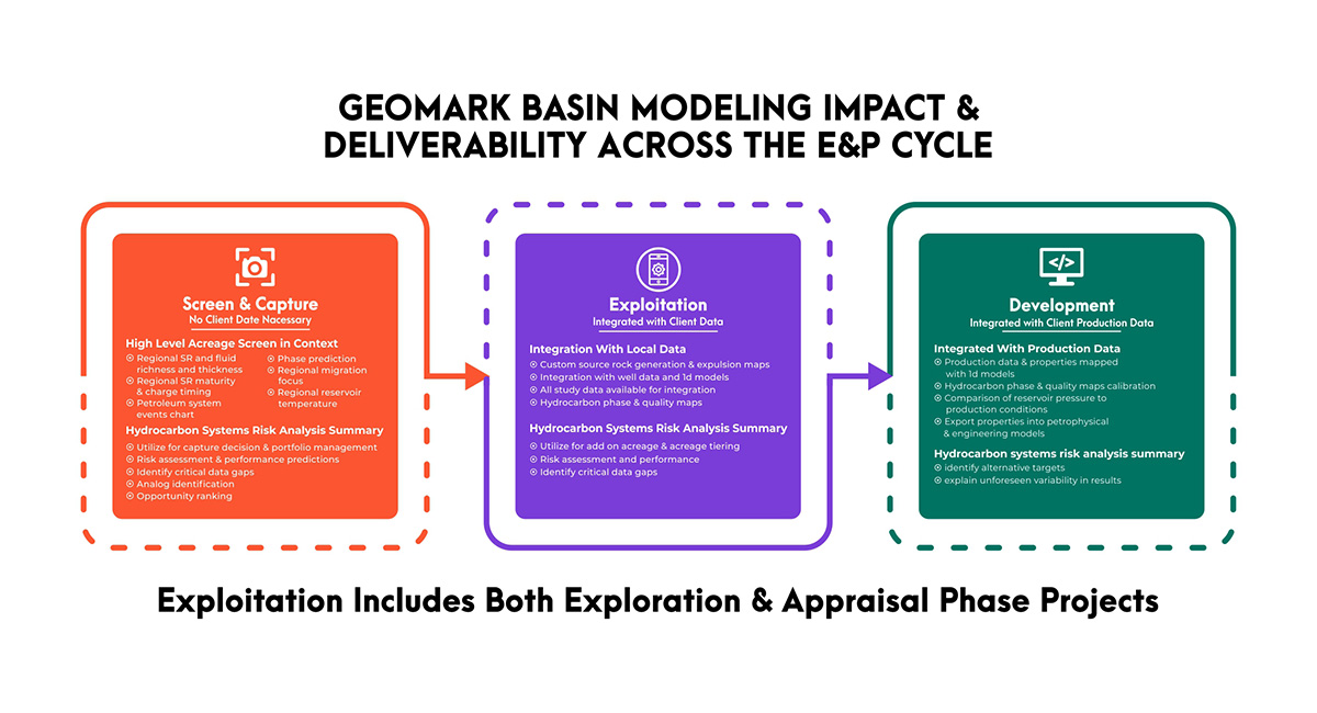
Additionally, models can be refined by integrating client specific data and providing updates as projects advance, always staying relevant to the questions at hand. GeoMark is a single stop for fully integrated geoscience solutions, from our lab to your field.
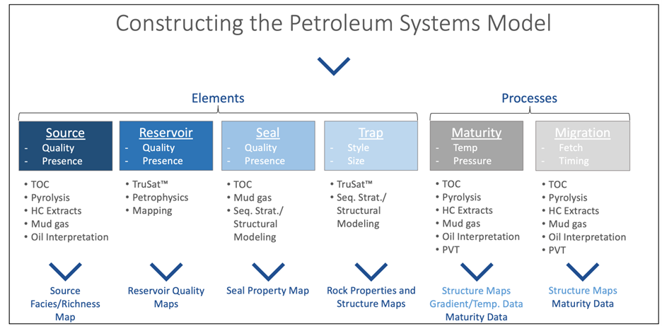
Petroleum Systems Modeling Overview
What is Basin Modeling?

How Do I Use it?
What Data Do I Need to Get Started?
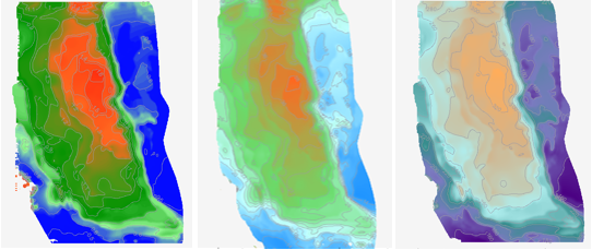
GeoMark will generate property maps such as reservoir pressure and temperature, generated oil volume, source rock maturity, etc., and provide them to your team as ready to use inputs for risk assessment and reservoir models. Figure 2 below shows example Maturity, Pressure and Temperature Maps from a recent study completed in a United States Resource Play. GeoMark can also provide the calibration data that was used in the models to constrain these property maps. GeoMark never provides a “black box” product and will openly disclose all data used in the models.
Petroleum Systems Modeling – Detailed Workflow
GeoMark will generate property maps such as reservoir pressure and temperature, generated oil volume, source rock maturity, etc., and provide them to your team as ready to use inputs for risk assessment and reservoir models. Figure 2 below shows example Maturity, Pressure and Temperature Maps from a recent study completed in a United States Resource Play. GeoMark can also provide the calibration data that was used in the models to constrain these property maps. GeoMark never provides a “black box” product and will openly disclose all data used in the models.
Databasing
Generation of 1D basin models
One Dimensional models are typically a starting place for petroleum systems models because they are a very tangible product. The final model will provide temperature and maturity estimates related to a well location that can be used to rank source rock and reservoir conditions that are critical to understand the economic potential of a play. They are built around wells or pseudo wells that geologic teams have already recognized as key data locations in their area of interest. The 1-D petroleum system model will use the stratigraphic information confirmed from drilling, including geologic ages, lithologies and depths. In addition, the section encountered during drilling can be extended, ideally to basement, by either collating regional information or inferring seismic data. Thus, the drilling information provides significant constraints to the model, but it will also test various geologic conditions that are not so easily measured such as missing section, thermal history and deposition rate. The project team describes the test conditions to the petroleum system modeler and several iterations can be run so that the team will fully understand the range of potential outcomes. This iterative step is an effective way to test the importance of certain elements. For example, often the source rock of a given play is not directly tested in a well but it might be projected on seismic. This source interval can be added onto known well information, but different depths/burial rates can be tested based on different seismic velocities. The result might be that regardless of seismic velocity, the projected source rock is clearly in the gas window. The project team now knows that the depth range of the source rock does not affect the outcome of its present day maturity window.
While the individual models are important useful in and of themselves, they are also important elements of further petroleum system work. The results of the 1-D models will be incorporated in future map based, 2-D and full 3D models.
Mapping of Model Properties
Petroleum Systems Modeling – Detailed Workflow
The last phase of the project is the final integration of all the previously described inputs and calibrated 1-D models with the depositional and history heat flow of the basin. The result is the final petroleum system interpretation and includes a description of identified organofacies, present day maturity of source rocks, likely migration pathways and relationship of hydrocarbon accumulations to source kitchens, and a discussion of PVT conditions and expected hydrocarbon phases (See Figure 4 for example migration map). Additionally, an estimate of volume of hydrocarbon generated and expelled can also be provided, as well as a high-level ranking of identified opportunities.
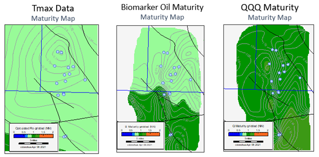
How is the basin model different than just gridded maps of data sets as described above? Measured properties describe the present-day condition of the sample but does not describe the history that resulted in that outcome. If we rely on present day maturity measurements, our assumptions about fluid properties and things such as kerogen conversion may be inaccurate. A case in point is the modern resource play in the Bakken Formation of the Williston Basin. Direct maturity estimates indicate that the source rock is immature, causing many investors to look elsewhere in the early days of resource plays. Petroleum System modelling that can account for varied kerogen types, depositional history and the potential for charge focus confirm what is known today through decades of production: the Bakken source rock generated significant hydrocarbons and is clearly not immature. A calibrated petroleum system model confirms this and highlights the best places to operate in the basin. Properties that are affected by change over time, such as maturity, overpressure, fetch, and erosion are best captured through petroleum system modeling.
A key aspect of petroleum system modeling is understanding the heat flow history of the source rocks in the basin of interest. When there is limited calibration data available, as is the case in many exploration projects, GeoMark believes in “bottoms up” temperature modelling, starting at the base of the lithosphere and initial formation of the basement, followed by an understanding of the depositional history up to present day, including key geologic events related to erosion, uplift, and thermal anomalies. Fortunately, in many of the most prolific basins, there is ample calibration data and more of a “top down” approach to temperature and pressure modeling can be applied. Integrating available PVT and fluid phase data when available is critical to understanding and predicting fluid at reservoir conditions.
Based on previous experience, it’s important to note that the best petroleum system models come from integrating of the modeling team with the subsurface interpretation team. GeoMark excels in open communication with to ensure that all available data and ranges are best captured in the model and that the end-user fully understands the model content and results. Prior to the final report and project conclusion, GeoMark will submit a draft review that should allow for additional feedback and improvement. The final report should not only address the project goals of completing a geochemical evaluation of the petroleum system but also provide the project team with confidence in its understanding of how to use the report to develop and pursue petroleum opportunities in the region. The most successful project will be a living project that the can referenced and expanded for years to come.